
Measuring land area is crucial for any construction project. It ensures proper planning and resource allocation.
Accurate land measurement is the first step to a successful build. Without it, you risk errors in material estimates and legal boundaries. Whether you’re a homeowner or a professional builder, understanding how to measure land area is vital. This guide will explain the methods and tools you need.
From simple tape measures to advanced GPS systems, we’ll cover it all. Ready to start your construction project on the right foot? Let’s dive into how you can measure your land area accurately.

Credit: www.spl.usace.army.mil
Essential Tools
Hey friends, today we are going to dive into the tools you need to measure land area for construction projects. Whether you’re building your dream house or setting up a new office, measuring the land accurately is crucial. Let’s talk about the essential tools you can use. We will look at both traditional and modern digital tools. Ready? Let’s go!
Traditional Measuring Tools
First up, the good old traditional tools. These tools have been around for ages. They are simple, and you don’t need a degree to use them.
- Measuring Tape: This is a basic tool. It’s a long tape marked with measurements. You stretch it out along the ground to measure distances.
- Chains: Like a measuring tape, but made of metal links. It’s used for longer distances and is durable.
- Surveyor’s Wheel: Also called a measuring wheel. You roll it along the ground, and it counts the distance for you.
These tools are great for small plots or when you need to measure quickly. But they might not be the best for big projects. The good news? There are modern tools too.
Modern Digital Tools
Next, let’s talk about modern digital tools. These tools use technology to make measuring easier and more accurate.
- Laser Distance Meters: These use a laser to measure distance. Point the laser at a spot, and it tells you how far away it is. Easy!
- GPS Devices: These use satellites to measure land. They are very accurate and good for large areas.
- Drones: Yes, drones! They fly over the land and take pictures. The pictures are then used to calculate the area. Super cool!
Modern tools can save you time and give you more accurate results. They might be a bit pricey, but they are worth it for big projects.
So, whether you choose traditional tools or modern digital ones, the key is to pick the right tool for your project. Happy measuring!
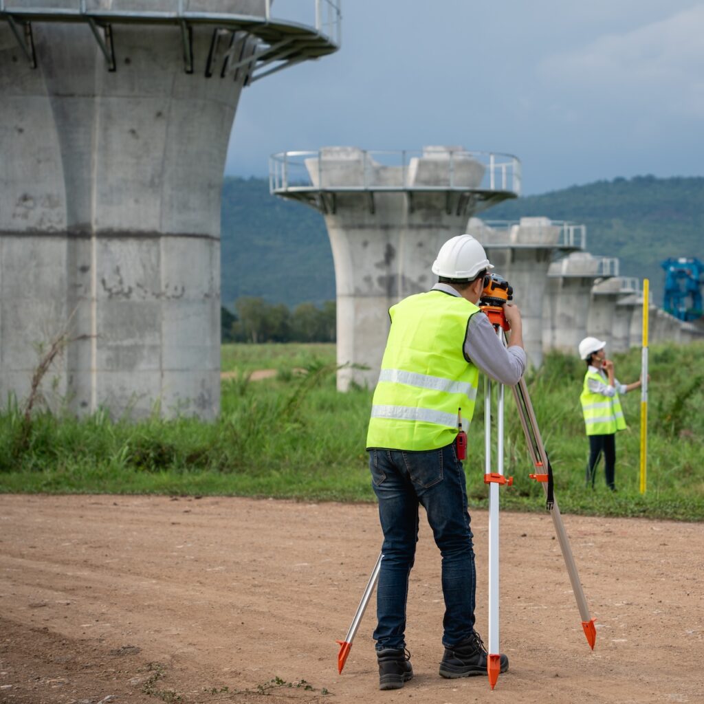
Surveying Techniques
Hey friends, measuring land for construction can seem like a big task. But with the right surveying techniques, it becomes much easier. Today, I’ll show you some simple methods you can use. These techniques will help you understand the land better and ensure your construction project goes smoothly.
Boundary Surveying
First, let’s talk about boundary surveying. This technique helps you know the exact limits of your land. Imagine you have a piece of land and you want to build a house. You need to know where your land starts and ends, right? Boundary surveying does just that.
Surveyors use tools like GPS and measuring tapes to mark the boundaries. They also check old maps and documents to make sure everything is accurate. Here’s a quick list of what boundary surveying involves:
- Using GPS devices
- Measuring with tapes
- Checking old maps
- Marking boundary lines
Example: I recently needed to build a fence around my yard. The surveyor came, used his GPS, and marked exactly where the fence should go. It was easy to follow his marks and build the fence in the right place.
Topographic Surveying
Next, let’s discuss topographic surveying. This technique shows you the shape and features of the land. Imagine you want to build on a hilly area. You need to know where the slopes and flat areas are. Topographic surveying helps with this.
Surveyors create maps that show the heights and features of the land. These maps include hills, valleys, trees, and buildings. Here’s what’s usually involved in topographic surveying:
- Measuring land features
- Creating detailed maps
- Using tools like theodolites and drones
Example: A friend of mine wanted to build a cabin on a hillside. The surveyor used a drone to map the area. The map showed where the cabin would fit best. Thanks to the map, the construction was smooth and the cabin stood perfectly on the slope.
By using these surveying techniques, you can be sure your construction project will start on the right foot. Remember, knowing your land well is the first step to building something great.
Using Gps Technology
Using GPS technology has transformed land measurement for construction projects. GPS, or Global Positioning System, offers precise and reliable data. This modern approach saves time and reduces human error. Learn how GPS can benefit your construction site.
Advantages Of Gps
GPS provides accurate measurements. This accuracy is crucial for laying out building foundations. Precise data means fewer mistakes. GPS devices are easy to use. Even non-experts can operate them. This user-friendly technology makes the process efficient. It also reduces the need for manual labor. Time-saving is another key benefit. Traditional methods take longer. With GPS, you can measure large areas quickly. This speed helps keep your project on schedule.
Implementing Gps In Land Measurement
First, acquire a reliable GPS device. Ensure it has up-to-date software. Place the device in the area you need to measure. Allow it to connect to satellites. This may take a few minutes. Once connected, walk around the perimeter of the land. The GPS will record the coordinates. Use these coordinates to map out the area. Many GPS devices come with mapping software. This software creates a visual map of the land. Export the data to your computer. Use it for planning and construction purposes. Regularly update your GPS device. This ensures continued accuracy and reliability.
Drone Technology
Hey friends, today we’re diving into something really cool – drone technology! Drones are not just flying toys; they are amazing tools for many industries, especially construction. They help measure land quickly and accurately. Let’s explore how drones can make your construction projects easier and more precise.
Benefits Of Drones
So, why use drones for measuring land? Here are some reasons:
- Speed: Drones can cover large areas fast. Much faster than traditional methods.
- Safety: They can access hard-to-reach places without putting anyone at risk.
- Cost-effective: Drones save money by reducing labor costs and speeding up the process.
- Detailed data: They provide high-resolution images and precise measurements.
How Drones Improve Accuracy
Accuracy is crucial in construction. And drones? They excel at it. Here’s how:
- High-resolution cameras: Drones are equipped with cameras that capture detailed images. These images help create accurate maps and 3D models.
- GPS technology: Drones use GPS to pinpoint exact locations. This ensures measurements are precise down to the centimeter.
- Advanced software: The data collected by drones is processed with advanced software. This software analyzes the images and measurements, providing reliable data for planning and construction.
I remember the first time I saw a drone in action on a construction site. It was like magic. The drone flew over the land, capturing every detail. Later, when the data was processed, the accuracy was spot on. It was incredible to see how much time and effort it saved.
To wrap it up, drone technology is a game-changer for measuring land area in construction projects. It’s fast, safe, cost-effective, and, most importantly, accurate. If you haven’t considered using drones yet, now might be the perfect time to start!
Calculating Land Area
Hey there! Today, we’re going to talk about something super useful: how to measure land area for construction projects. This might sound tricky at first, but don’t worry, we’ll break it down into simple steps. Whether you’re planning to build a new house, a park, or any other structure, knowing the exact size of your land is crucial. Ready to dive in? Let’s get started with calculating land area.
Mathematical Formulas
First, let’s look at some basic math. These formulas are super handy if you have a simple, regular-shaped piece of land. For example, if your land is a rectangle, you can use this formula:
- Rectangle: Length x Width
Easy, right? Just measure the length and width of your land, multiply them, and you’ve got your area.
But what if your land is a triangle? No problem! Use this formula:
- Triangle: (Base x Height) / 2
Again, measure the base and height, plug them into the formula, and you’re all set.
For more complex shapes, you might need to divide the land into smaller, regular shapes, calculate each area separately, and then add them all together.
Software Solutions
Not a fan of math? That’s okay! There are plenty of software tools that can help you calculate land area with ease. Here are a few popular options:
- Google Earth: This free tool allows you to draw the boundaries of your land on a map and instantly see the area.
- AutoCAD: If you’re working on a larger project, this professional software offers precise measurements and detailed drawings.
- GIS (Geographic Information Systems): These systems provide advanced mapping and analysis tools, perfect for larger or more complex sites.
Using software can save you a lot of time and effort. Plus, it often gives you more accurate results than manual calculations.
So, whether you prefer using simple math or high-tech tools, there’s a method for everyone. Happy measuring!

Credit: www.amazon.sa
Legal Considerations
When measuring land area for construction projects, legal considerations are crucial. Understanding the legal framework ensures compliance and avoids potential disputes. Several key aspects need attention, particularly land ownership laws and the necessary permits and approvals.
Land Ownership Laws
Land ownership laws vary by region. It is important to know who owns the land. This prevents legal issues during construction. Always verify the land title. Ensure it is clear and valid. Consult with local authorities or a legal expert. This ensures all ownership documents are legitimate.
Permits And Approvals
Before starting construction, obtain the required permits. Building without permits can lead to fines. It can also cause project delays. Check with your local government for specific requirements. Some areas need environmental impact assessments. Others may require zoning approvals. Always submit accurate land measurements. This helps in getting the necessary approvals faster.
Expert Tips
Measuring land area for construction projects can be challenging. But, with expert tips, you can ensure the accuracy and precision needed. These tips will help avoid common mistakes and achieve precise measurements.
Avoiding Common Mistakes
Many make errors when measuring land. One common mistake is not considering the land’s topography. Hills and slopes can affect measurements. Use tools that account for elevation changes. Another mistake is relying on outdated maps. Always use the latest survey maps. They provide the most current data.
Overlooking boundary markers can also cause issues. Always locate and verify boundary markers. This ensures you measure the correct land area. Lastly, avoid assuming all land parcels are regular shapes. Many are irregular. Measure each side carefully to get accurate results.
Ensuring Precision And Accuracy
Precision is vital in land measurement. Use the right tools. A measuring wheel is good for smaller areas. For larger areas, a GPS device is better. It offers more accuracy. Double-check all measurements. Errors can occur, so verify each one.
Hire a professional surveyor for complex projects. They have the expertise and tools needed. They ensure all measurements are precise. Keep a record of all measurements. Documenting helps if you need to verify data later. Always cross-reference your findings with official records. This ensures you have the correct data.
Credit: rfeng.biz
Frequently Asked Questions
How To Calculate The Construction Area?
To calculate construction area, measure the length and width of each floor. Multiply length by width. Sum the areas of all floors.
How To Calculate Buildable Land Area?
Calculate buildable land area by subtracting non-buildable features (setbacks, easements) from the total land area. Use zoning regulations to determine restrictions.
What Is The Formula To Calculate Land Area?
To calculate land area, use the formula: Length x Width for rectangles or base x height / 2 for triangles.
How Do You Measure Land For A Building?
To measure land for a building, use tools like a measuring tape or laser distance measurer. Survey the area, noting boundaries and dimensions. Ensure accuracy by double-checking measurements.
Conclusion
Measuring land area for construction projects is essential. It ensures accuracy and saves costs. Use the right tools and methods. Understand your project needs and local regulations. Always double-check your measurements. Precise measurements lead to successful projects. Follow these steps for better results.
Your project will benefit from careful planning.

Rakib Sarwar is a seasoned professional blogger, writer, and digital marketer with over 12 years of experience in freelance writing and niche website development on Upwork. In addition to his expertise in content creation and online marketing, Rakib is a registered pharmacist. Currently, he works in the IT Division of Sonali Bank PLC, where he combines his diverse skill set to excel in his career.