
Photogrammetry is a powerful tool for construction site measurement. It uses photos to create accurate 3D models.
In the construction industry, precise measurements are crucial. Traditional methods can be time-consuming and complex. Photogrammetry offers a faster, more efficient alternative. By capturing images from various angles, you can generate detailed models of the site. This technique can save time and reduce errors.
It also allows for easy updates and sharing of data. In this blog post, we’ll explore how to use photogrammetry for construction site measurement. We’ll cover the basics and provide clear steps to get you started. Whether you’re new to the field or looking to improve your skills, this guide will help you understand and apply photogrammetry effectively.
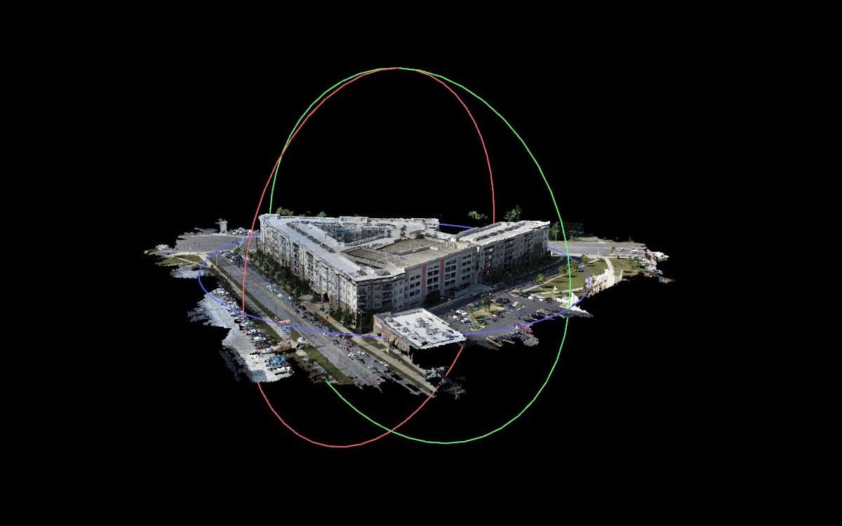
Credit: flyguys.com
Introduction To Photogrammetry
Photogrammetry is an exciting field that merges photography and science. It is used to measure and map the world around us. This technique is particularly useful in construction. It provides accurate and detailed site measurements. Understanding photogrammetry can greatly benefit construction projects.
History And Evolution
Photogrammetry has a rich history. It started in the mid-19th century. The first known use was in topographic mapping. Early techniques were manual and time-consuming. The process involved taking photos from different angles and plotting points by hand.
Technological advancements have transformed photogrammetry. Modern methods use digital cameras and software. Drones and satellites capture images from above. These tools make the process faster and more accurate. Today, photogrammetry is an essential tool in many industries.
Importance In Construction
In construction, accurate measurements are crucial. Photogrammetry helps achieve this. It captures detailed images of the site. These images provide precise measurements. They help in planning and design. The data ensures structures are built correctly.
Photogrammetry also saves time and money. Traditional methods are labor-intensive. They take days or weeks. Photogrammetry completes the task in hours. This efficiency speeds up construction projects. It reduces labor costs and increases productivity.
Using photogrammetry improves safety. It allows remote site inspections. This minimizes the risk of accidents. Construction teams can assess hazardous areas from a safe distance.
Fundamental Principles
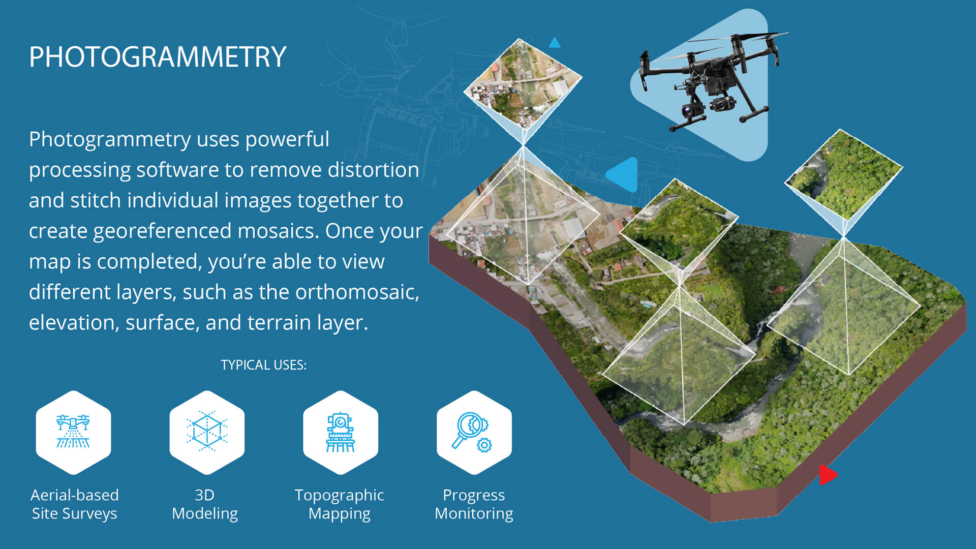
Understanding photogrammetry begins with its fundamental principles. This process involves capturing measurements and data from photographs. These measurements then get converted into accurate 3D models.
For construction, photogrammetry provides detailed site information. It helps with planning and monitoring progress. Let’s explore the basic concepts and key techniques involved.
Basic Concepts
Photogrammetry relies on taking multiple photos from different angles. These photos overlap and create a 3D representation of the site. The software analyzes these images to produce accurate measurements.
Light and angles play a crucial role. Clear images with proper lighting ensure better results. Consistent camera settings help maintain accuracy.
Key Techniques
First, choose the right equipment. High-resolution cameras or drones work best. Drones provide aerial views, covering large areas quickly.
Next, plan your flight path. Ensure that your photos overlap by at least 60%. This overlap is vital for accurate 3D modeling. Consistent altitude and angles improve data quality.
Use software for processing images. Many programs offer user-friendly interfaces. They guide you through importing, processing, and analyzing your data.
Finally, verify the results. Compare the 3D model to known measurements. Make any necessary adjustments to improve accuracy.
Essential Equipment
Photogrammetry is an effective method for construction site measurement. It requires specific tools to ensure accuracy and efficiency. This section will cover the essential equipment needed to get started with photogrammetry in construction.
Cameras And Drones
A good camera is crucial for photogrammetry. Use a high-resolution camera to capture detailed images. Digital SLR cameras are popular choices. They provide high image quality and flexibility.
Drones are also essential. They can reach hard-to-access areas. Drones equipped with high-resolution cameras capture comprehensive site images. Choose a drone with GPS capabilities for precise data.
Software Tools
Photogrammetry software processes the images. It transforms photos into accurate 3D models. Many software options are available. Some popular choices include Agisoft Metashape and Pix4D.
These tools offer user-friendly interfaces. They include features for aligning images and creating 3D maps. Ensure the software you choose is compatible with your camera and drone. Look for software that offers regular updates and customer support.
Site Preparation
Hey friends, today we are diving into the essentials of using photogrammetry for construction site measurement. Before you get started, proper site preparation is crucial. Think of it as setting up a stage before the big performance. This ensures that everything runs smoothly and accurately. Let’s explore some key steps for preparing your site effectively.
Planning And Safety
First things first: planning and safety. This is like the foundation of a house. Without it, everything else can fall apart. Here’s what you need to do:
- Assess the site: Walk around and take a good look. Note any obstacles or hazards.
- Create a plan: Outline what needs to be measured and how you will do it. Write it down. Simple is better.
- Safety first: Ensure everyone knows the safety rules. Wear helmets and safety vests. Better safe than sorry.
- Team briefing: Discuss the plan with your team. Make sure everyone is on the same page.
Setting Up Control Points
Next up, setting up control points. Think of these as your map’s landmarks. They help guide the way and ensure accuracy.
- Select locations: Choose clear and stable spots around the site. Avoid places that might move or change.
- Mark the points: Use visible markers like paint or flags. Make them easy to spot from different angles.
- Measure coordinates: Use GPS or a total station to get the exact coordinates. Write them down carefully.
- Double-check: Verify the accuracy of your points. A small mistake here can cause big problems later.
Setting up control points is like setting the pins in bowling. You want them precise and steady to get a perfect strike.
In summary, proper site preparation ensures your photogrammetry process runs smoothly. By planning and ensuring safety, and carefully setting up control points, you pave the way for accurate and efficient measurements. Stay tuned for more tips on making the most out of photogrammetry in construction!
Data Collection
Data collection is a crucial step in using photogrammetry for construction site measurement. Accurate data ensures precise measurements and detailed 3D models. This section will guide you through the essential steps for effective data collection.
Capturing Images
High-quality images are key to successful photogrammetry. Use a camera with a high resolution. Ensure proper lighting conditions to avoid shadows. Take overlapping photos from different angles. This helps create a complete 3D model.
Drone Flight Patterns
Drones make data collection easier and faster. Plan your drone flight patterns carefully. Use a grid pattern to cover the entire site. Maintain a consistent altitude for uniform image quality. Fly the drone slowly to avoid blurry images.
Data Processing
Hey there! Today, we’re diving into a fascinating topic: how to use photogrammetry for construction site measurement. This process involves capturing images to create detailed 3D models. But there’s a crucial step in the middle: data processing. Let’s break it down into simple steps so you can easily follow along.
Image Stitching
First things first, we need to talk about image stitching. Imagine you have taken hundreds of photos of a construction site. These photos overlap, showing different angles and perspectives. The goal is to combine all these images into one big picture. Just like putting together a puzzle.
Here’s how it’s done:
- Software analyzes each photo.
- It finds common points in overlapping images.
- Then, it stitches them together to create a seamless view.
Pretty cool, right? This stitched image will be our base for the next step.
Generating 3d Models
Now that we have a single, detailed image, it’s time to create a 3D model. This step is like turning a flat map into a miniature version of the actual site. The software will use the stitched images to estimate depth and dimensions.
Here’s the process in simple terms:
- Software identifies the height and depth of each point in the images.
- It then builds a 3D model by connecting these points.
- Finally, it creates textures to make the model look realistic.
And there you have it! A 3D model that shows the construction site in great detail. Easy to visualize and measure.
Why is this important? Well, accurate 3D models help in planning, monitoring, and inspecting construction projects. It’s like having a virtual tour of the site anytime you need it.
So, next time you hear about photogrammetry, you’ll know exactly what’s going on behind the scenes. It’s all about turning photos into a detailed, 3D reality.
Analyzing Results
Analyzing results is a crucial step in photogrammetry for construction site measurement. This process ensures the data collected is accurate and useful. By carefully examining the results, you can make informed decisions about your construction project. It involves measuring distances, calculating volumes, and verifying the accuracy of your models. Let’s dive into these key aspects of analyzing results.
Measuring Distances
Measuring distances is one of the primary uses of photogrammetry. By capturing images from various angles, you can create a 3D model of the construction site. This model allows you to measure distances with high precision. To measure distances, use specialized software that processes the images. Mark the start and end points of the distance you need to measure. The software then calculates the distance based on the 3D model. This method is accurate and saves time compared to traditional methods.
Volume Calculations
Volume calculations are another important application of photogrammetry in construction. Accurate volume measurements are essential for tasks like earthworks, material estimation, and project planning. To calculate volumes, capture images of the area from multiple angles. Use photogrammetry software to generate a 3D model. Define the area you want to measure within the model. The software calculates the volume based on the defined area. This process ensures accurate and reliable volume measurements. It also helps in tracking progress and managing resources effectively.
Credit: volatusaerospace.com
Applications In Construction
Hey friends! Today, we are diving into the world of photogrammetry. This magical technique uses photos to measure and map out construction sites. But why is it so important in construction? Let’s find out!
Photogrammetry is like having a superpower in the construction world. It helps in many areas, from site surveys to progress monitoring. It’s like having a perfect view of your construction site, right in your hands. Let’s explore these applications in more detail.
Site Surveys
Site surveys are crucial for any construction project. They help you understand the land you are working on. With photogrammetry, site surveys become a breeze. Here’s how:
- Accurate Measurements: Photogrammetry provides precise measurements of the land. This helps in planning the construction better.
- Quick Data Collection: You can gather data quickly by taking multiple photos. No more long hours spent on the site.
- Detailed Maps: Create detailed 3D maps of the site. This helps in visualizing the project before starting the work.
Imagine you are building a house. With photogrammetry, you can see a 3D map of your plot. It’s like having a blueprint in 3D!
Progress Monitoring
Keeping track of progress is vital in construction. You need to know if things are on schedule. Photogrammetry makes this easy. Here’s how:
- Regular Updates: Take photos regularly to create a timeline of the project. See how things change over time.
- Identify Issues Early: Spot any problems quickly. If something doesn’t look right, you can fix it before it becomes a big issue.
- Share Progress: Share the 3D maps with your team or clients. Everyone stays informed and on the same page.
Think about it like this: You are baking a cake. You check it regularly to make sure it’s baking perfectly. Photogrammetry does the same for construction projects.
So there you have it! Photogrammetry is a fantastic tool for construction. Whether you are surveying a site or monitoring progress, it makes everything easier and more efficient. Have you tried using photogrammetry in your projects? Let us know how it went!
Challenges And Solutions
Using photogrammetry for construction site measurement can be challenging. Yet, with proper understanding, solutions are achievable. This section explores the common issues you might face. Then, it provides best practices to overcome them.
Common Issues
One common issue is poor image quality. Blurry or low-resolution images lead to inaccurate measurements. Environmental factors like weather or light can affect image clarity. Another issue is the alignment of images. Misalignment can distort the 3D model. This leads to incorrect data.
Processing time is also a concern. Large datasets take longer to process. This can delay project timelines. Technical knowledge is another challenge. Not everyone is familiar with photogrammetry software. Lack of training can result in errors.
Best Practices
To overcome these issues, ensure good image quality. Use high-resolution cameras. Take photos in good lighting conditions. Avoid taking pictures in harsh weather. Proper planning is key. Make sure to cover all angles of the site.
For alignment, use ground control points. These help in aligning images accurately. Regularly check the alignment during the process. This prevents errors early on.
Speed up processing by using powerful hardware. Ensure your computer has enough RAM and storage. Keep your software updated. Updates often improve processing speed.
Invest in training. Learn the basics of photogrammetry software. Many online courses are available. Hands-on practice can also help. The more you practice, the better you get.
By addressing these challenges, photogrammetry becomes more effective. It enhances construction site measurement accuracy and efficiency.
Future Trends
Hey friends, today we’re diving into the future of photogrammetry in construction site measurement. It’s exciting to think about where this technology is headed. We’ll look at upcoming trends and how they might change the way we work. Ready? Let’s get started!
Technological Advancements
Technology is always evolving. And photogrammetry is no different. Here are a few advancements we can expect:
- Better Cameras: Cameras are getting better each year. Higher resolution means more accurate measurements.
- Faster Processing: Computers are speeding up. This means faster results from your photogrammetry software.
- Cloud Computing: More and more software is moving to the cloud. This makes it easier to store and share data.
Remember when we used to wait forever for a computer to process images? Those days are almost over!
Industry Innovations
Innovation isn’t just about technology. It’s also about how we use it. Here are some industry innovations to watch out for:
- Integration with Drones: Drones are becoming more common on construction sites. They can take photos from angles that humans can’t reach.
- Real-time Monitoring: Imagine getting real-time updates on your project. This is becoming possible with new software.
- Augmented Reality (AR): AR can overlay photogrammetry data onto the real world. This helps in visualizing projects before they are built.
These innovations are not just cool—they make our work easier. And more accurate. Who wouldn’t want that?
So, what do you think? The future of photogrammetry in construction site measurement looks bright. With new technologies and innovations, we can expect better and faster results. Stay tuned to see how these trends develop. And maybe, just maybe, you’ll find yourself using them sooner than you think.

Credit: www.pix4d.com
Frequently Asked Questions
How Is Photogrammetry Used In Construction?
Photogrammetry creates accurate 3D models from photos in construction. It aids site surveys, measurements, and progress tracking efficiently.
How Is Photogrammetry Used In Surveying?
Photogrammetry in surveying creates accurate maps and 3D models from photographs. It measures distances between points using images.
What Is Photogrammetry For Measurement?
Photogrammetry for measurement uses photographs to capture accurate dimensions and spatial relationships of objects. It creates 3D models from 2D images. This method is cost-effective and precise, widely used in surveying, architecture, and engineering.
What Is The Application Of Photogrammetry In Civil Engineering?
Photogrammetry in civil engineering is used for creating accurate maps, 3D models, and measurements of terrain and structures. It helps in planning, monitoring, and managing construction projects efficiently.
Conclusion
Photogrammetry offers a precise way to measure construction sites. It saves time and reduces errors. The process is simple and effective. Use drones or cameras to capture images. Then, software converts these images into 3D models. These models help in planning and execution.
This technology enhances project accuracy and efficiency. It’s a valuable tool for modern construction. Adopting photogrammetry can significantly improve your workflow. Start using it today and see the benefits.

Rakib Sarwar is a seasoned professional blogger, writer, and digital marketer with over 12 years of experience in freelance writing and niche website development on Upwork. In addition to his expertise in content creation and online marketing, Rakib is a registered pharmacist. Currently, he works in the IT Division of Sonali Bank PLC, where he combines his diverse skill set to excel in his career.